Ecosonda Kolida SDE 28s+

KOLIDA
SDE28s-A2503220
excl. Entrega kg
  • Descripción
  • Mas Info
  • Especificaciones

SDE-28s Ecosonda digital de una sola frecuencia La ecosonda Kolida SDE-28S+ es un control industrial y una ecosonda digital con una pantalla TFT-LCD de 12.1 pulgadas integrada, unidad de control industrial, unidad de sondeo, procesador de datos, unidad de memoria interna, varios tipos de interfaces y I / O device

ECOSONDA Kolida SDE 28S,La ecosonda hidrográfica de precisión Kolida SDE 28S+ es un sistema muy completo de navegación y control hidrológico que permite trabajar hasta 300 mt de forma simple y con un resultado profesional. El potente software PowerNav incorpora herramientas para la toma y tratado de datos, así como importar directamente archivos DXF de fondo. Podrá usarla para diseño de diferentes estructuras portuarias y pluviales como son canales de navegación, etc, además que proporciona un entorno adecuado para tareas de supervisión, tales como dragados, rellenos o mantenimiento de ríos y presas
VIDEO Echo Sounder SDE-28s Installation and Operation


KOLIDA SDE-28S+ echo sounder is a kind of industrial control and digital echo sounder which is integrated with the 12.1-inch TFT-LCD screen, industrial control unit, echo sounding unit, data processor, internal memory unit and kinds of interfaces and I/O devices. The special design makes it dust-proof, waterproof, shockproof. It collects depth measurement, graphical navigation, positioning data, water depth data acquisition together. All these features make the instrument strong compatibility, stable performance and reliable accuracy.


Onboard Software

SDE-28S+ (for depth measurements)

·Real-time vivid display of graphic and data, easy approach to underwater waves

·Integrated sound velocity calculation for more accurate results

·Smart alarm for shallow water and  "No echo" tracking to secure hydrographic operations

·Real-time display of the water depth value tracking lines, easy to be compared with underwater waves
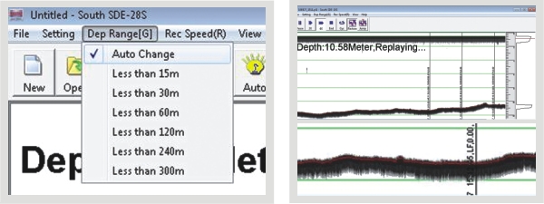
28Sb.jpg

Auto change of depth range                                                          Real-time display


PowerNav (for navigation purpose)


·New software kernel, faster processing and more stable

·Professional Engineering map sheet and data management, wizard-style parameter setting

·High compatibility, flexible to import graphs and data, connectible to all GPS devices and echo sounders

·Modular designed, meets diverse needs of hydrographic engineering projects

SDE28D
  • Max. power consumption [W]
    400
  • Min. external DC power [V]
    9
  • Max. external DC power [V]
    18
  • Min. external AC power [V]
    110
  • Max. external AC power [V]
    260
  • Weight in air [kg]
    7.5
  • Width [m]
    0.14
  • Length [m]
    0.35
  • Height [m]
    0.29
  • Software platform
    Windows XP
  • Min. depth of operation [m]
    0.3
  • Max. depth of operation [m]
    2000
  • Min. frequency [kHz]
    20
  • Max. frequency [kHz]
    200
  • Min. power output [W]
    300
  • Max. power output [W]
    800
  • Min. beam angle [deg]
    7
  • Max. beam angle [deg]
    7
  • Depth resolution [m]
    0.01
  • Max. sounding rate [Hz]
    30
  • Real-time sound velocity and temperature profile inclusion
    Y